Tumwater, Washington
Tumwater, Washington | |
|---|---|
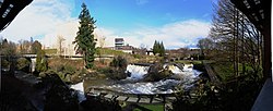
 Panoramic view of the upper falls and the former Olympia Brewery, 2011 | |
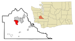
 Location of Tumwater, Washington | |
| Coordinates: 47°0′28″N 122°54′40″W / 47.00778°N 122.91111°W | |
| Country | United States |
| State | Washington |
| County | Thurston |
| Incorporated | November 25, 1869[1] |
| Government | |
| • Type | Mayor–council |
| • Mayor | Debbie Sullivan[2] |
| Area | |
| • Total | 17.76 sq mi (46.00 km2) |
| • Land | 17.50 sq mi (45.32 km2) |
| • Water | 0.26 sq mi (0.67 km2) |
| Elevation | 174 ft (53 m) |
| Population | |
| • Total | 25,350 |
| • Estimate (2021)[5] | 25,844 |
| • Density | 1,372.80/sq mi (530.04/km2) |
| Time zone | UTC-8 (PST) |
| • Summer (DST) | UTC-7 (PDT) |
| ZIP codes | 98501, 98511, 98512 |
| Area code | 360 |
| FIPS code | 53-72905 |
| GNIS feature ID | 1512742[6] |
| Website | ci.tumwater.wa.us |

Tumwater is a city in Thurston County, Washington, United States. The population was 25,350 at the 2020 census.[4] The city is situated near where the Deschutes River enters Budd Inlet, the southernmost point of Puget Sound; it also borders the state capital of Olympia to the north. Tumwater is the oldest permanent Anglo-American settlement on Puget Sound.[7]
Etymology
[edit]Tumwater was originally called "New Market" by American settlers, and under the latter name was platted in 1845.[8] The present name is derived from Chinook Jargon and means "waterfall".[8] A post office called Tumwater was established in 1863.[9]
History
[edit]The site of Tumwater and Tumwater Falls has been home to Southern Lushootseed-speaking peoples known as the Steh-Chass / Stehchass or Statca'sabsh (a subtribe of the Sahewamish (Sahe'wabsh), an subgroup of the Nisqually people; who became part of the post-treaty Squaxin Island Tribe) for thousands of years. "Steh-Chass" is the Lushootseed name for Budd Inlet, Deschutes River and the Tumwater Falls area, and for an important village of the Statca'sabsh.
Tumwater was incorporated as a town on November 25, 1869,[10][11] and as a city in 1875.[12]
The construction of Interstate 5, which was completed in 1958, required the demolition of 100 buildings in downtown Tumwater. Major businesses had already relocated northeast to Tumwater Square, which remains a local shopping center. The Tumwater Historic District was listed on the National Register of Historic Places in 1978 to preserve remnants of downtown amid plans to widen Interstate 5.[13]
Geography
[edit]Tumwater is located 2 miles south of the neighboring state capital of Olympia.
According to the United States Census Bureau, the city has a total area of 14.49 square miles (37.53 km2), of which, 14.32 square miles (37.09 km2) is land and 0.17 square miles (0.44 km2) is water.[14]
Climate
[edit]This region experiences warm and dry summers, with average monthly temperatures between 71.6 °F (22 °C) and 98.1 °F (36.7 °C). According to the Köppen Climate Classification system, Tumwater has a very warm-summer Mediterranean climate, abbreviated "Csb" on climate maps.[15]
Demographics
[edit]Based on per capita income, one of the more reliable measures of affluence, Tumwater ranks 89th of 522 areas in the state of Washington to be ranked. It is also the highest rank in Thurston County.
| Census | Pop. | Note | %± |
|---|---|---|---|
| 1870 | 354 | — | |
| 1880 | 171 | −51.7% | |
| 1890 | 410 | 139.8% | |
| 1900 | 270 | −34.1% | |
| 1910 | 490 | 81.5% | |
| 1920 | 472 | −3.7% | |
| 1930 | 793 | 68.0% | |
| 1940 | 955 | 20.4% | |
| 1950 | 2,725 | 185.3% | |
| 1960 | 3,885 | 42.6% | |
| 1970 | 5,373 | 38.3% | |
| 1980 | 6,705 | 24.8% | |
| 1990 | 9,976 | 48.8% | |
| 2000 | 12,698 | 27.3% | |
| 2010 | 17,371 | 36.8% | |
| 2020 | 25,350 | 45.9% | |
| 2021 (est.) | 25,844 | [5] | 1.9% |
| U.S. Decennial Census[16] 2020 Census[4] | |||
2010 census
[edit]As of the 2010 census,[17] there were 17,371 people, 7,566 households, and 4,460 families living in the city. The population density was 1,213.1 inhabitants per square mile (468.4/km2). There were 8,064 housing units at an average density of 563.1 per square mile (217.4/km2). The racial makeup of the city was 85.0% White, 1.7% African American, 1.2% Native American, 4.8% Asian, 0.5% Pacific Islander, 1.6% from other races, and 5.2% from two or more races. Hispanic or Latino of any race were 6.2% of the population.
There were 7,566 households, of which 28.9% had children under the age of 18 living with them, 40.9% were married couples living together, 13.1% had a female householder with no husband present, 4.9% had a male householder with no wife present, and 41.1% were non-families. 31.6% of all households were made up of individuals, and 9.7% had someone living alone who was 65 years of age or older. The average household size was 2.27 and the average family size was 2.83.
The median age in the city was 35 years. 27% of residents were under the age of 18, 10% from 18 to 24; 31.7% were between the ages of 25 and 44; 26.8% from 45 to 64; and 13% were 65 years of age or older. The gender makeup of the city was 47.7% male and 52.3% female.
2000 census
[edit]As of the 2000 census, there were 12,698 people, 5,659 households, and 3,253 families living in the city. The population density was 1,276.1 people per square mile (492.7/km2). There were 5,953 housing units at an average density of 598.2 per square mile (231.0/km2). The racial makeup of the city was 88.41% White, 1.39% African American, 1.24% Native American, 3.90% Asian, 0.36% Pacific Islander, 1.50% from other races, and 3.21% from two or more races. Hispanic or Latino of any race were 4.08% of the population.
There were 5,659 households, out of which 28.3% had children under the age of 18 living with them, 41.5% were married couples living together, 12.3% had a female householder with no husband present, and 42.5% were non-families. 33.7% of all households were made up of individuals, and 10.2% had someone living alone who was 65 years of age or older. The average household size was 2.20 and the average family size was 2.82.
In the city, the age distribution of the population shows 23.2% under the age of 18, 10.9% from 18 to 24, 29.5% from 25 to 44, 23.0% from 45 to 64, and 13.5% who were 65 years of age or older. The median age was 36 years. For every 100 females, there were 89.8 males. For every 100 females age 18 and over, there were 84.5 males.
The median income for a household in the city was $43,329, and the median income for a family was $54,156. Males had a median income of $41,778 versus $32,044 for females. The per capita income for the city was $25,080. About 4.3% of families and 8.5% of the population were below the poverty line, including 9.5% of those under age 18 and 5.2% of those age 65 or over.
Arts and culture
[edit]Tumwater is home to the Davis Meeker Garry Oak Tree, a 400-year-old historic tree located at the Olympia Regional Airport on Old Highway 99. Named after Ezra Meeker and Jack Davis, an environmentalist who helped save the oak in 1984 during a highway improvement project, the tree was a waypoint on the Cowlitz Trail. The oak tree is listed on the Tumwater Register of Historic Places.[18] In 2024, the city attempted to remove the specimen but efforts were paused due to public protests and litigation. The tree was considered a danger to passing motorists and in poor health.[19][20][21][22]
Government
[edit]Due to the city being located in close proximity to the state capital, Tumwater is home to many state government offices, including the Washington State Department of Corrections, the Washington State Department of Labor and Industries, the Washington State Department of Health, the Washington State Office of the Insurance Commissioner, the Washington State Department of Revenue and the Office of the Attorney General.[23]
The City of Tumwater itself is a non-charter Code City and uses a Mayor-Council form of government. The Mayor is elected as a chief executive officer and advised by seven council members who act as policymakers and provide guidelines and performance objectives.[24] The Tumwater City Council elections are held in odd-numbered years.[25]
Education
[edit]The Tumwater School District is home to numerous schools including Tumwater High School and Black Hills High School.[26]

References
[edit]- ^ "Tumwater History". Archived from the original on July 30, 2009. Retrieved May 26, 2009.
- ^ "Meet the Tumwater Mayor and City Council". City of Tumwater. Retrieved April 6, 2024.
- ^ "2019 U.S. Gazetteer Files". United States Census Bureau. Retrieved August 7, 2020.
- ^ a b c "Explore Census Data". United States Census Bureau. Retrieved May 15, 2022.
- ^ a b "City and Town Population Totals: 2020-2021". United States Census Bureau. June 21, 2022. Retrieved June 21, 2022.
- ^ "US Board on Geographic Names". United States Geological Survey. October 25, 2007. Retrieved January 31, 2008.
- ^ "History," Archived September 2, 2021, at the Wayback Machine City of official website. Retrieved January 28, 2020.
- ^ a b "A brief history". City of Tumwater. Archived from the original on August 21, 2014. Retrieved March 31, 2018.
- ^ "Post Offices". Jim Forte Postal History. Retrieved March 31, 2018.
- ^ "Our History". City of Tumwater. Retrieved June 26, 2024.
- ^ "Tumwater Settled By Simmons Party". The News Tribune. April 7, 1953. p. E8. Retrieved June 26, 2024 – via Newspapers.com.
- ^ "Thurston County Place Names: A Heritage Guide" (PDF). Thurston County Historical Commission. 1992. p. 90. Archived from the original (PDF) on March 24, 2020. Retrieved March 28, 2018.
- ^ Batcheldor, Matt (December 7, 2008). "I-5 at 50: It's changed the face of the region". The Olympian. p. A1. Retrieved February 23, 2023 – via Newspapers.com.
- ^ "US Gazetteer files 2010". United States Census Bureau. Archived from the original on January 25, 2012. Retrieved December 19, 2012.
- ^ "Tumwater, Washington Köppen Climate Classification (Weatherbase)".
- ^ United States Census Bureau. "Census of Population and Housing". Retrieved October 11, 2013.
- ^ "U.S. Census website". United States Census Bureau. Retrieved December 19, 2012.
- ^ Johnson, Carleen (July 11, 2024). "Tumwater seeks to hire arborist as 400-year-old oak tree faces potential ax". The Chronicle. The Center Square. Retrieved July 18, 2024.
- ^ Flatt, Courtney (June 3, 2024). "Court revokes protective order for historic Tumwater oak tree". Northwest Public Broadcasting. Retrieved June 10, 2024.
- ^ Vinson, Ty (June 3, 2024). "Thurston County judge dissolves order preventing removal of historic tree". The Chronicle (Centralia, Washington). The Olympian. Retrieved June 10, 2024.
- ^ Mikkelsen, Drew (June 5, 2024). "Tumwater mayor pauses tree removal after 'passionate pleas'". King 5 News (Seattle). Retrieved June 10, 2024.
- ^ Vinson, Ty (June 6, 2024). "Tumwater mayor pauses plan to cut down historic Davis-Meeker oak tree. Here's why". The Olympian. Retrieved June 10, 2024.
- ^ "Contact Us Archived December 1, 2012, at the Wayback Machine." Washington State Department of Corrections. Retrieved on December 7, 2009.
- ^ ""Government"". City of Tumwater. Retrieved August 6, 2023.
- ^ "Here are the candidates you'll be choosing from in this fall's local elections". The Olympian. May 20, 2023. Retrieved August 7, 2023.
- ^ "Tumwater School District". Archived from the original on May 25, 2009. Retrieved May 23, 2009.
External links
[edit]- City of Tumwater, Washington (official website)

