
Miquelon-Langlade
Miquelon-Langlade | |
|---|---|
 Miquelon village | |
 Flag .svg) Coat of arms | |
 Location of the commune (in red) within Saint Pierre and Miquelon | |
Location of Miquelon-Langlade  | |
| Coordinates: 47°06′00″N 56°22′45″W / 47.100000°N 56.3792°W | |
| Country | France |
| Overseas collectivity | Saint Pierre and Miquelon |
| Government | |
| • Mayor (2020–2026) | Franck Detcheverry[1] |
| Area 1 | 205 km2 (79 sq mi) |
| Population (2019)[2] | 580 |
| • Density | 2.8/km2 (7.3/sq mi) |
| Time zone | UTC−03:00 |
| • Summer (DST) | UTC−02:00 |
| INSEE/Postal code | 97501 /97500 |
| Elevation | 0–240 m (0–787 ft) |
| Website | http://www.miquelon-langlade.com |
| 1 French Land Register data, which excludes lakes, ponds, glaciers > 1 km2 (0.386 sq mi or 247 acres) and river estuaries. | |
Native name: Miquelon–Langlade | |
|---|---|
 | |
| Geography | |
| Location | Atlantic Ocean |
| Archipelago | Saint Pierre and Miquelon |
| Adjacent to | Gulf of Saint Lawrence |
| Area | 110 km2 (42 sq mi) |
| Highest point | Morne de la Grande Montagne (240 m (790 ft)) |
| Administration | |
| Overseas collectivity | Saint Pierre and Miquelon |
| Largest Commune | Miquelon-Langlade |
| Demographics | |
| Demonym | Miquelonnais(e)(s) |
| Population | 626 (2012) |
| Languages | French |
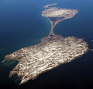
Miquelon-Langlade (French pronunciation: [miklɔ̃ lɑ̃ɡlad]) is the larger but less populated of the two communes (municipalities) making up the French overseas collectivity of Saint Pierre and Miquelon, located 22 km (14 mi) to the south of Newfoundland in the Gulf of St. Lawrence.[4] It consists of three geological islands: Miquelon, Langlade and Le Cap, connected with tombolos. The communal seat is the settlement of Miquelon, on the northern tip, where the entire island's permanent population of 580 (as of 2019) is located. Miquelon Airport provides flights to Montreal and to nearby Saint-Pierre Airport.
Miquelon island, also known as Grande Miquelon, is situated between Le Cap Island to the north and Langlade island (also called Petite Miquelon) to the south.[5] Miquelon and Langlade are connected by a narrow tombolo (sandy isthmus).
Toponymy
[edit]The name Miquelon purportedly derived from a Basque nickname for "Michael" (Mikel). In 1579, the names Micquetõ and Micquelle appeared for the first time in French Basque mariner Martin de Hoyarçabal's maritime pilot. The name evolved over time into Miclon, Micklon, and finally Miquelon (Mikelune in Basque).[3][6]
Geography
[edit]Located in the Gulf of St. Lawrence, west of Newfoundland's Burin Peninsula, Miquelon-Langlade covers a total land area of 205 km2 (79 sq mi). It comprises three islands connected by tombolos: Le Cap in the north, Miquelon (Grand Miquelon) in the center, and Langlade (Petite Miquelon) in the south.
A tombolo sandspit called La Dune connects Miquelon and Langlade, that formed in the 18th century that is 12 km (7.5 mi) long and 6 to 100 m (20 to 328 ft) wide.[3][7] In the eighteenth century it was still possible to sail a boat between Miquelon and Langlade, but by the end of that century La Dune had closed in to form an isthmus between the islands.[8]
The tombolo connecting Miquelon and Le Cap is 3 km (1.9 mi) long and in places less than 100 m (330 ft) wide.
The island of Saint Pierre is across a treacherous and foggy 6 km (3.7 mi) strait that fishermen named "The Mouth of Hell" (French: La Gueule de L'Enfer) that has been the site of more than 600 shipwrecks.[3][9]
Miquelon
[edit]Miquelon's coastline includes numerous sand and pebble beaches enclosing lagoons, as well as high rocky cliffs standing up to 25 m (82 ft) on the east coast. Its geology consists of slightly metamorphosed post-Ordovician volcanic rocks, mainly rhyolites with breccias, andesites and basalts. On the south of the Miquelon Island is the Grand Barachois, a large lagoon which is host to a large population of seals and other wildlife. Miquelon is also a well known destination for bird watching.[5]
Langlade
[edit]Located at 3 mi (4.8 km) west of Saint Pierre Island, Langlade is an ancient peneplain drained by numerous short rivers, including the Belle, the largest, which flows to the northwest.[10] The coast of Langlade is lined with steep cliffs, except to the northwest.
Climate
[edit]The climate is typical of the North Atlantic and the Labrador Current, with frequent storms and winds that exceed 60 km/h (37 mph) for nearly six months of the year. The summers are cool and foggy. The average annual temperature is 5.5 °C (41.9 °F).[5] Köppen–Geiger climate classification system classifies its climate as sub-Arctic (Dfc).[11] Summers are mild while winters are cold. It receives precipitation all year.
| Climate data for Miquelon-Langlade | |||||||||||||
|---|---|---|---|---|---|---|---|---|---|---|---|---|---|
| Month | Jan | Feb | Mar | Apr | May | Jun | Jul | Aug | Sep | Oct | Nov | Dec | Year |
| Mean daily maximum °C (°F) | −0.1 (31.8) |
−0.6 (30.9) |
1.5 (34.7) |
5.3 (41.5) |
9.7 (49.5) |
13.7 (56.7) |
17.9 (64.2) |
19.3 (66.7) |
16.5 (61.7) |
11.5 (52.7) |
7.1 (44.8) |
2.2 (36.0) |
8.7 (47.6) |
| Daily mean °C (°F) | −3.5 (25.7) |
−4.2 (24.4) |
−1.7 (28.9) |
2 (36) |
5.7 (42.3) |
9.6 (49.3) |
13.9 (57.0) |
15.4 (59.7) |
12.5 (54.5) |
7.8 (46.0) |
4 (39) |
−0.8 (30.6) |
5.1 (41.1) |
| Mean daily minimum °C (°F) | −6.8 (19.8) |
−7.7 (18.1) |
−4.9 (23.2) |
−1.2 (29.8) |
1.8 (35.2) |
5.6 (42.1) |
10 (50) |
11.6 (52.9) |
8.5 (47.3) |
4.1 (39.4) |
0.9 (33.6) |
−3.8 (25.2) |
1.5 (34.7) |
| Average precipitation mm (inches) | 124 (4.9) |
106 (4.2) |
101 (4.0) |
102 (4.0) |
101 (4.0) |
105 (4.1) |
98 (3.9) |
109 (4.3) |
118 (4.6) |
137 (5.4) |
137 (5.4) |
132 (5.2) |
1,370 (54) |
| Average rainy days (≥ 1 mm) | 8 | 6 | 5 | 6 | 7 | 6 | 7 | 5 | 6 | 9 | 9 | 10 | 84 |
| Source 1: Climate-Data.org (altitude: 1m)[11] | |||||||||||||
| Source 2: Storm247.com for rainy days[12] | |||||||||||||


Etymology
[edit]The name Miquelon is of Basque origin and means "Michael", as several fishermen with this name were established in the island. In 1579, the names Micquetõ, Micquelle appeared for the first time in Martin de Hoyarçabal's navigational pilot. The name evolved over time into Miclon, Micklon, and finally Miquelon.
The residents are known as Miquelonnais(e)(s).[13]
Demographics
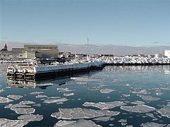
[edit]Miquelon-Langlade consists of the commune (also called Miquelon-Langlade), with a population of 626 in 2012. The majority of the residents live in the village of Miquelon, located in the north of the island near Le Cap, [13] north of a shallow lagoon (barachois) and has a small harbour protected with constructed breakwaters along the eastern side of the isthmus.
On the northern coast of Langlade, there are settlements at the coves of Anse du Gouvernement, Anse aux Soldats and Le Ruisseau Debons, consisting mainly of holiday cottages.[14][15]
The population of Miquelon-Langlade is mainly of Basque and Acadian ancestry.
Transportation
[edit]Miquelon Airport is located adjacent to Miquelon village; Air Saint-Pierre operates regularly scheduled daily flights to Saint-Pierre Airport.
SPM Ferries provides service to and from Saint Pierre town from both Miquelon village and Anse du Gouvernement on Langlade. SPM also connects Miquelon town directly with Fortune, Newfoundland, Canada once or twice weekly. A ferry service connects Miquelon town with Anse du Gouvernement on Langlade in summer months.[16]
The main asphalt road runs from the capital along the eastern coast of Miquelon, across the Langlade tombolo and ending in Le Ruisseau Debons on Langlade.
Facilities
[edit]Schools
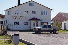
[edit]- Ecole du socle de Miquelon, which houses:[17] As of the 2014–2015 school year the junior high school had 25 students.[18]
- the private contracted nursery school / preschool Soeur Hilarion
- public elementary school Les Quatre Temps
- public junior high school Collège de Miquelon
The government high school / sixth-form programmes serving Miquelon are at Lycée-Collège d'État Émile Letournel on Saint-Pierre island.
Museums and activities
[edit]The Maison de la Nature et de L'Environnement ("Nature and Environment Center") provides self-guided tours of both the Cormorandière Valley and of the whole island. It hosts the art/craft vendor Art passion. Its Centre d'interprétation ("interpretation centre") features exhibits on geography, climate, biodiversity, and history through and interactive permanent axibilts that leads visitors through nature habitats.[19]
The Musée de Miquelon ("museum of Miquelon") explains the origin of the island's people, including objects, customs and activities.[19]
In summer, Saveurs Fermièrres ("farm flavours"), a goat farm, teaches about goats and cheesemaking, and offers tastings of local farm products.[19]
There are numerous hiking routes: Le Chemin des Boeufs, Pointe Plate, Les Buttes dégarnies et la Grand Barachois, Belliveau, Le Cap de Miquelon, La Tête Pelé, and Les Trois Sapins. There is a nature observatory Observatoire du Grand Barachois and several camping areas including Mirande and Trois Sapins.[19][20]
Other
[edit]At Miquelon village other facilities include (as of 2024):[19]
- The Centre Médical de Miquelon (basic medical care; more advanced services are available in Saint-Pierre and St. John's)
- Football (soccer) pitch Stade de l'Avenir ("stadium of the future") of the Association Sportive Miquelonnaise (Miquelon sports association)
- Police, fire and ferry stations, library, post office, public restrooms, tourist information office
- Government offices: mairie, prefecture, and délégation territoriale
- 2 restaurants Auberge de L'Île and Brian
- 1 bakery Miquelon, 1 bank Caisse d'Épargne, 1 bar/disco Salle entre nous, 1 coffee shop Art passion, 1 ice cream stand (seasonal), 1 snack bar À choix, grocery store SAS Domane [21]
- Hotel Auberge de L'Île, bed and breakfast Au p'tit kakawi, seasonal rental accommodations Chez Adrien and La Passerelle
- ATM, bike rental Chez Adrien, church, gas station, laundry, pharmacy, photo studio My Little Touch, veterinary clinic
- Air Saint-Pierre office, airport, 2 car rental establishments (Max Giradin and Auto Action), providers of guided tours Auberge de L'Île and Escapade Insulaire ("island escapade")
At Anse du Gouvernement
[edit]At Anse du Gouvernement on Langlade as of 2024, there is a bar, ferry station, grocery store, health care point, public restroom and restaurant, as well as the Sainte-Thérèse Roman Catholic chapel and the Centre de vacances de Langlade summer camp.[19]
Landmarks
[edit]- Ampersand (&) sculpture,[19]
Festivals and events
[edit]- Les 25 km de Miquelon ("the 25 km of Miquelon") half marathon race
- Bastille Day celebration with games, food, fireworks and dancinh
- Le Festival des Produits de Mer (Seafood Festival)
- Le Dunefest music festival
Gallery
[edit]-
 Miquelon shore
 -
 The north coast of Miquelon, next to Le Cap
 -
 The village of Miquelon seen from the west
 -
 Aerial view of Miquelon village
 -
 Houses in Miquelon village
 -
 Miquelon's school building
 -
 Milestone to Miquelon village
 -
 The port of Miquelon
 -
 Acadien monument
 -
 Flag of Miquelon–Langlade
 -
 View from the Pointe Plate lighthouse on Langlade towards Miquelon
 -
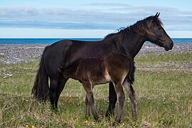 Horse on Langlade isthmus
 -
 The road from Miquelon to Langlade
 -
 Langlade: Anse du Gouverneur cove.jpg
 -
 Snowcovered isthmus
 -
 Bridge over the Belle Rivière (river)


See also
[edit]- Saint Pierre
- Municipal governments in Saint Pierre and Miquelon
- History of Saint Pierre and Miquelon
- List of islands of France
- List of islands in the Atlantic Ocean
External links
[edit]- Official website
- Le Phare: Association of Tourism Professionals
- Local Airline Air Saint-Pierre
- 2012 French Presidential Election
References
[edit]- ^ "Répertoire national des élus: les maires" (in French). data.gouv.fr, Plateforme ouverte des données publiques françaises. 13 September 2022.
- ^ Téléchargement du fichier d'ensemble des populations légales en 2019, INSEE
- ^ a b c d St. Pierre & Miquelon Business Law Handbook: Strategic Information and Laws. International Business Publications. p. 26. ISBN 9781438771090. Retrieved 16 November 2016.
- ^ Limits of Oceans and Seas (PDF). International Hydrographic Organization. 1953. Archived from the original (PDF) on October 8, 2011.
- ^ a b c Bird, Eric. Encyclopedia of the World's Coastal Landforms. Springer Science & Business Media. pp. 163–165. ISBN 9781402086380. Retrieved 16 November 2016.
- ^ "1579 – Voyages Avantureux, Martin de Hoyarçabal". Grand Colombier. Retrieved 16 November 2016.
- ^ Transport Miquelonnais Archived 2011-07-24 at the Wayback Machine
- ^ "Transport Miquelonnais – Geographical situation". Archived from the original on 2011-07-24. Retrieved 2010-06-12.
- ^ Les Français peints par eux-mêmes: encyclopédie morale du dix-neuvième siècle (in French). L. Curmer. 1840. p. 640. Retrieved 16 November 2016.
- ^ Saint Pierre & Miquelon. Territorial Collectivity of France, in the North America Archived 2012-03-30 at the Wayback Machine
- ^ a b "Climate: Miquelon-Langlade – Climate graph, Temperature graph, Climate table". Climate-Data.org. Retrieved 2013-12-10.
- ^ "Commune de Miquelon-Langlade in Saint-Pierre-et-Miquelon, Saint Pierre and Miquelon – Climate". Storm247.com. Archived from the original on 2013-12-14. Retrieved 2013-12-10.
- ^ a b Edward, David A. O.; Lane, Robert (2013). Edward and Lane on European Union Law. Edward Elgar Publishing. p. 81. ISBN 9780857931054. Retrieved 16 November 2016.
- ^ "Présentation de Langlade". Les Coureurs de l'Isthme (in French). 2019-05-10. Retrieved 2022-02-18.
- ^ "Vacances de printemps au ruisseau Debons - Saint-Pierre et Miquelon la 1ère". Saint-Pierre et Miquelon la 1ère (in French). 2018-05-09. Retrieved 2022-02-18.
- ^ "Le site de débarquement des passagers du Jeune France saturé à Langlade - Saint-Pierre et Miquelon la 1ère". Saint-Pierre et Miquelon la 1ère (in French). 2018-08-02. Retrieved 2022-02-18.
- ^ "Ecole du socle de Miquelon." National Education Service of Saint Pierre and Miquelon. Retrieved on September 14, 2016.
- ^ "Ecole du socle de Miquelon >Présentation." National Education Service of Saint Pierre and Miquelon. Retrieved on September 14, 2016.
- ^ a b c d e f g St. Pierre and Miquelon Visitor Guide. SPM Tourisme. 2024. pp. 91–131.
- ^ Guide nature: découvrez 15 balades à Saint-Pierre & Miquelon. Saint-Pierre et Miquelon: Maison de la nature et de l'environnement. 2012. ISBN 9782954231402. Retrieved 5 August 2024.
- ^ "SAS Domane". Facebook. Retrieved 5 August 2024.
Places adjacent to Miquelon-Langlade | ||||||||||||||||
|---|---|---|---|---|---|---|---|---|---|---|---|---|---|---|---|---|
| ||||||||||||||||