
Saarlouis
{{Infobox German location
|type = Town
|image_photo = LudwigskircheSaarlouis.jpg
|image_caption = The Ludwigskirche (Saint Louis Church)
|image_coa = DEU Saarlouis COA.svg
|image_flag = Flag of Saarlouis.svg
|coordinates = 49°19′N 6°45′E / 49.317°N 6.750°E
|image_plan = Saarlouis in SLS.svg
|state = Saarland
|district = Saarlouis
|elevation = 181
|area = 43.27
|postal_code = 66740
|area_code = 06831
|licence = SLS
|Gemeindeschlüssel = 10 0 44 115
|divisions = 8
|website = www.saarlouis.de
|mayor = Marc SpeicherCite error: A <ref> tag is missing the closing </ref> (see the help page).

The industrial port in Saarlouis-Roden is Germany's 13th largest inland port.[1] Saarlouis is also a manufacturer of chocolate.[2]
Politics
[edit]Saarlouis is part of the Saarlouis (electoral district) in the Bundestag, represented by Peter Altmaier.
Transport
[edit]Saarlouis has a station on the Saar railway that provides hourly connections to Saarbrücken and Trier.
It is connected to Saarbrücken by the A 620 and with Luxembourg by the A 8.
Twin towns – sister cities
[edit] Saint-Nazaire, France (1969)
 Eisenhüttenstadt, Germany (1986; the first West and East German town twinning)
 Matiguás, Nicaragua (1986)
Notable people
[edit]- Michel Ney (1769–1815), Marshal of France
- Heinrich Marx (1777–1838), lawyer and father of Karl Marx
- Martin de Bervanger (1795–1865), priest
- Charles-Nicolas Peaucellier (1832–1913), general and inventor of the Peaucellier–Lipkin linkage
- Eduard von Knorr (1840–1920), admiral of the Imperial German Navy and chief of the East Asia Squadrons
- Paul Emil von Lettow-Vorbeck (1870–1964), colonial general and politician
- Alois Spaniol (1904–1959), Nazi Party leader of the Saar
- Esther Béjarano (1924–2021), survivor of the Women's Orchestra of Auschwitz
- Oskar Lafontaine (born 1943), politician (SPD, The Left)
- Rainer Rupp (born 1945), spy
- Gabriel Clemens (born 1983), darts player
- Ralf Altmeyer (born 1966), virologist
- Heiko Maas (born 1966), politician (SPD)
Gallery
[edit]-
 The Deutsches Tor (German Gate)
 -
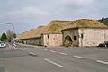 The Kasematten (The Casemates)
 -
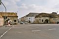
 The Commander's Office and the Großer Markt (Great Market)
 -
 The Vauban Island and the memorial of Michel Ney
 -
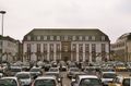
 The town hall
 -
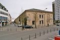 The Kaserne No. VI (Barracks No. VI, now home of a museum and a public library)
 -
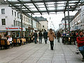 The Französische Straße (French Street), now a pedestrian zone
 -
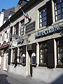 Birthplace of Michel Ney, now a French Restaurant
 -
 The Protestant church
 -
 The geographic centre


See also
[edit]References
[edit]- ^ Neitzel, Dörte (3 June 2022). "Die größten deutschen Binnenhäfen" [Germany's largest inland ports]. Technik + Einkauf. Retrieved 5 July 2022.
- ^ "Saarlouis – Germany".
- ^ "Städtepartnerschaften". saarlouis.de (in German). Saarlouis. Retrieved 18 March 2021.
External links
[edit]![]() Media related to Saarlouis at Wikimedia Commons
Media related to Saarlouis at Wikimedia Commons
- Official website
 (in German)
 - Fire Brigade of Saarlouis (Saarlouis has one of the oldest Volunteer fire departments of Germany)
- History of Saarlouis 1 and Saarlouis 2 (renamed to Saarlautern) 1936–1945
- History of one of the most famous companies in Saarlouis: Donnerbräu
Towns and municipalities in Saarlouis (district) | ||
|---|---|---|
| International | |
|---|---|
| National | |
| Geographic | |